Learning from detailed regulation plans, the Master Plan of Belgrade and Google Earth
| 16 October 2007 - Comments (0) | Reflections |
 Using public information such as the detailed regulation plans, the Master Plan of Belgrade to 2021 and tools such as the popular Google Earth, you can learn a lot on land and construction. You can plan way in advance the parts that will become interesting and those that will not be. Through an example using the land for our project Amadeo, we will show the valuable information it is possible to extract.
Detailed regulation plans
A great part of Belgrade is covered by detailed regulation plans. Those plans, prepared by the Belgrade Urban Planning Bureau, provide information on everything related to the city organization. In particular, they provide regulations on whether and what it is possible to build on a given plot of land and the detailed lay out for roads and infrastructure. Those plans are public information and anybody should be able to get a digital copy.
As an example, we will look at the one covering the zone where is the land of our project Amadeo located. This detailed regulation plan is covering parts of Zvezdara and Voždovac. Below is a global view of the complete plan. What is interesting is to get the plan in a digital format to be able to zoom at an arbitrary precision.
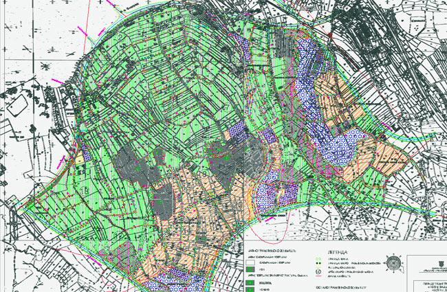
Global view of the detailed regulation plan of parts of Zvevdara and Voždovac (source Gradska opština Zvezdara).
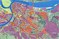
Using detailed regulation plan as an overlay for Google Earth
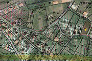
Let's first have a look at the area around our land in Google Earth. You can see the existing roads and constructions. The satellite imagery in Google Earth is usually excellent and is getting better by the day. That particular picture is no more than 2 years old. Still, at the speed illegal constructions are popping up, there are still some new constructions that do not appear on it. Not shown either is that the road going around Amadeo project's land has been newly made.

The current situation of the land for the Amadeo project (source Google Earth).
What is interesting to know when you buy a land or an apartment is what will happen around your property whether good or bad. This is why it is essential to have a look at the detailed regulation plan. Below is the same view as above in the detailed regulation plan.
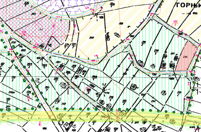
Detailed regulation plan around the land for the Amadeo project. Amadeo's land is shown in red color. The new main circular road is shown in yellow.
So as you can see, the new circular belt road, a major new axis in the Master Plan of Belgrade, will pass close by. In fact it will be conveniently close while being far enough not to be an annoyance. This is very good new as it will certainly greatly increase the value of the property. Besides, several minor roads will be created.
It is possible to combine the 2 views above to place the information from the detailed regulation plan as an overlay of the map from Google Earth. The view below shows the result. As you can see, it is much more informative. You are able to visualize, on site, the planned infrastructure. You can also immediately see the limit of plots directly on the land.
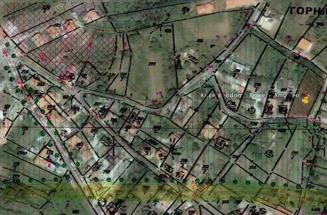
A view of how the detailed regulation plan applies to the current situation and how things will change (overlay by Lionel Mestre).
This technique can be a powerful tool to analyze potential areas of interest.
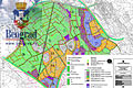
Using the Master Plan of Belgrade to 2021
For the parts of Belgrade that are not covered by a detailed regulation plan, it is still possible to see the planned infrastructure and zoning using a high resolution version of the Master Plan of Belgrade to 2021. Combined with Google Earth, you can produce very informative views.
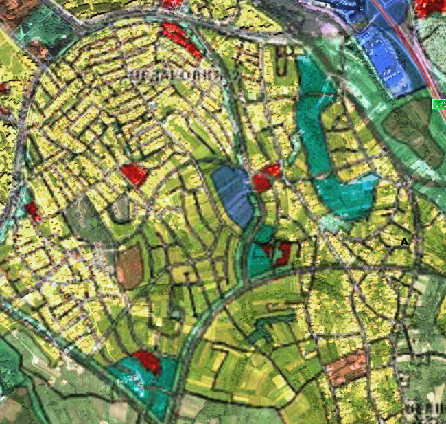
Let's look at the large area around our land. Part of it is covered with the detailed regulation plan and part of it is not. When you look at this area in Google Earth, it's hard to imagine how much change will take place.
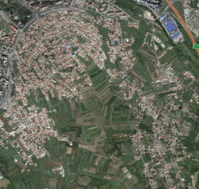
Current situation around our land (marked with a black A) (source Google Earth).
To visualize how much the area will change over the next few years, let's look at the Master Plan for the exact same area. Belgrade is a fast growing city and a simple look at the Master Plan below shows you that most of the fields (in yellow) are going to be built and that everything will be irrigated by major road infrastructures.
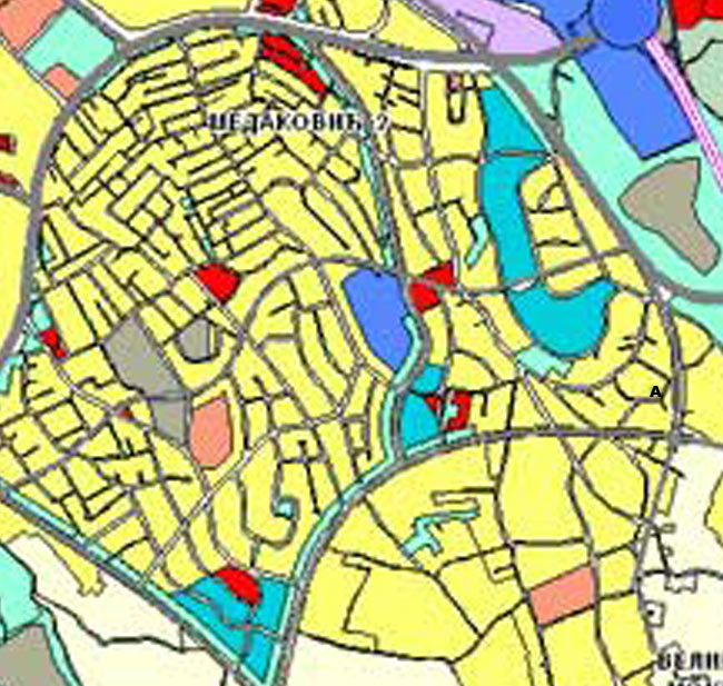
Zoom from the Master Plan of Belgrade to 2021 of the same area. Our land is marked with a black A (source Master Plan of Belgrade to 2021).
Legend: yellow: residential area, red: commercial zones and city centers, purple: industrial zones, blue: sport and sport objects, green: green space, orange: public services and objects, light yellow: agricultural lands.
The big problem with the view above is that you loose all referals to existing lands and objects. So, as before, we merge the two views above. You can see the result below. When you know the area, using this view, it is incredibly easy to know where is a plot of land located on the master plan.
A view of how the Master Plan of Belgrade to 2021 applies to the current situation and how things will change (overlay by Lionel Mestre).
Regarding our land, we actually learn one more thing that was not shown on the detailed regulation plan. There will be a new road joining the 2 new belt roads. That road is passing just off on the right of our land marked A. Yet it does not touch it as there will be a line of existing houses in between. So our land will be ideally accessible from the new major axis. You can imagine the effect on the value of an excellent quality apartment built on that land.
Such a simple analysis shows you how good can be an investment in the medium term.
Conclusion
We live in a constant changing environment. Being able to use the information readily available today makes possible to anticipate those changes and to make smart decisions. In real-estate that kind of information can make a difference worth many thousands of euros. That is true, whether you are simple buyer of an apartment or an investor.